


DroneDeploy
Description of DroneDeploy
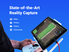
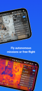
DroneDeploy is the most popular app worldwide for drone mapping. Fly your DJI drone autonomously with just two taps on your iOS/Android device. The free DroneDeploy app provides easy automated flight and data capture, enabling high quality interactive maps for analysis, 3D modeling and more. Process your images with DroneDeploy to analyze, annotate and share your maps with others directly from within the app.
DroneDeploy users have mapped millions of acres in more than 100 countries.
Great for a wide range of aerial image and mapping applications, including crop scouting, mapping and surveying, construction and mining stockpile measurement, roof and insurance inspection and more.
Compatible with DJI’s latest drones:
- Mavic Pro
- Phantom 4 Pro
- Phantom 4
- Phantom 3 Standard,
- Phantom 3 4K,
- Phantom 3 Pro,
- Phantom 3 Advanced,
- Inspire 1 and Inspire 1 Pro (including support for the Zenmuse x5 camera)
- Matrice 100.
- Matrice 600
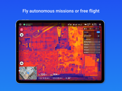
Autonomous flight highlights::
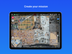
- Simple flight planning
- Auto-flight and camera settings
- Automated pre-flight safety checks
- Rotate flight direction
- Auto-takeoff, flight and landing
- Live stream First Person View (FPV)
- Smart auto exposure adjustments
- Disable auto-flight and resume control with a single tap
- Multi-flight mission support and starting waypoint selection for continued missions
- Offline flight capabilities
- Custom parameters (altitude, front and side image overlap, camera settings)
- In-app support
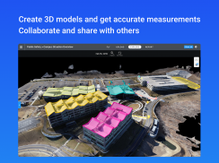
Integrated professional-grade map and 3D model highlights:
- High accuracy maps and models
- In-field inspection on any device
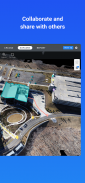
- Team collaboration (annotations and messaging) on any device
- Real time distance, area and volume measurements
- Orthomosaic, NDVI, Digital Elevation and Surface Models, and more
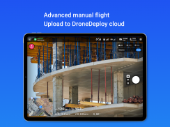
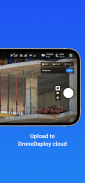
Upload images from your drone’s SD card to www.dronedeploy.com to access interactive maps, shareable 3D models and more directly from within the app.
Please fly responsibly and obey all local regulations.
What’s new
This release introduces a fully integrated drone mapping experience with a brand new user interface. The app includes enhanced flight and data capture capabilities, in addition to an entirely new ability to analyze, annotate and share your drone maps directly from within the app.
New flight features include:
- Flight planning information (area, duration, resolution) when defining area of interest
- Rotate flight direction to select optimum flight path for given conditions
- Select the starting waypoint when continuing a multi-flight mission
- Live stream First Person View (FPV)
New map and 3D model features:
- Interact with your maps and 3D models directly within the app from anywhere
- Analyze NDVI, Elevation and more
- Measure distance, area and volume from within the app
- Add comments and have private conversations about your maps and 3D models
- Securely export and share your maps and models with others
Please join us in improving and discussing the app at http://forum.dronedeploy.com/c/dji
Learn more about getting started with Inspire/P3 here:
http://forum.dronedeploy.com/t/getting-started-guide/61</br></br></br></br></br></br></br></br></br></br></br></br></br></br></br></br></br></br></br></br></br></br></br></br></br></br></br></br></br></br></br></br></br></br></br></br></br></br></br></br></br></br></br></br></br></br></br></br></br></br></br></br></br></br></br></br></br></br></br></br></br></br></br></br>
DroneDeploy - Version 5.48.0
(23-09-2024)DroneDeploy - APK Information
APK Version: 5.48.0Package: com.dronedeploy.betaLatest Version of DroneDeploy
Other versions


 3.55
3.55
 3.17
3.17
Apps in the same category

You may also like...
 3.433.724.072.474.39


